
Discover Northeast Folly Beach: The Old Coast Guard Station, Graffiti Path & a Wild Piece of Lowcountry History
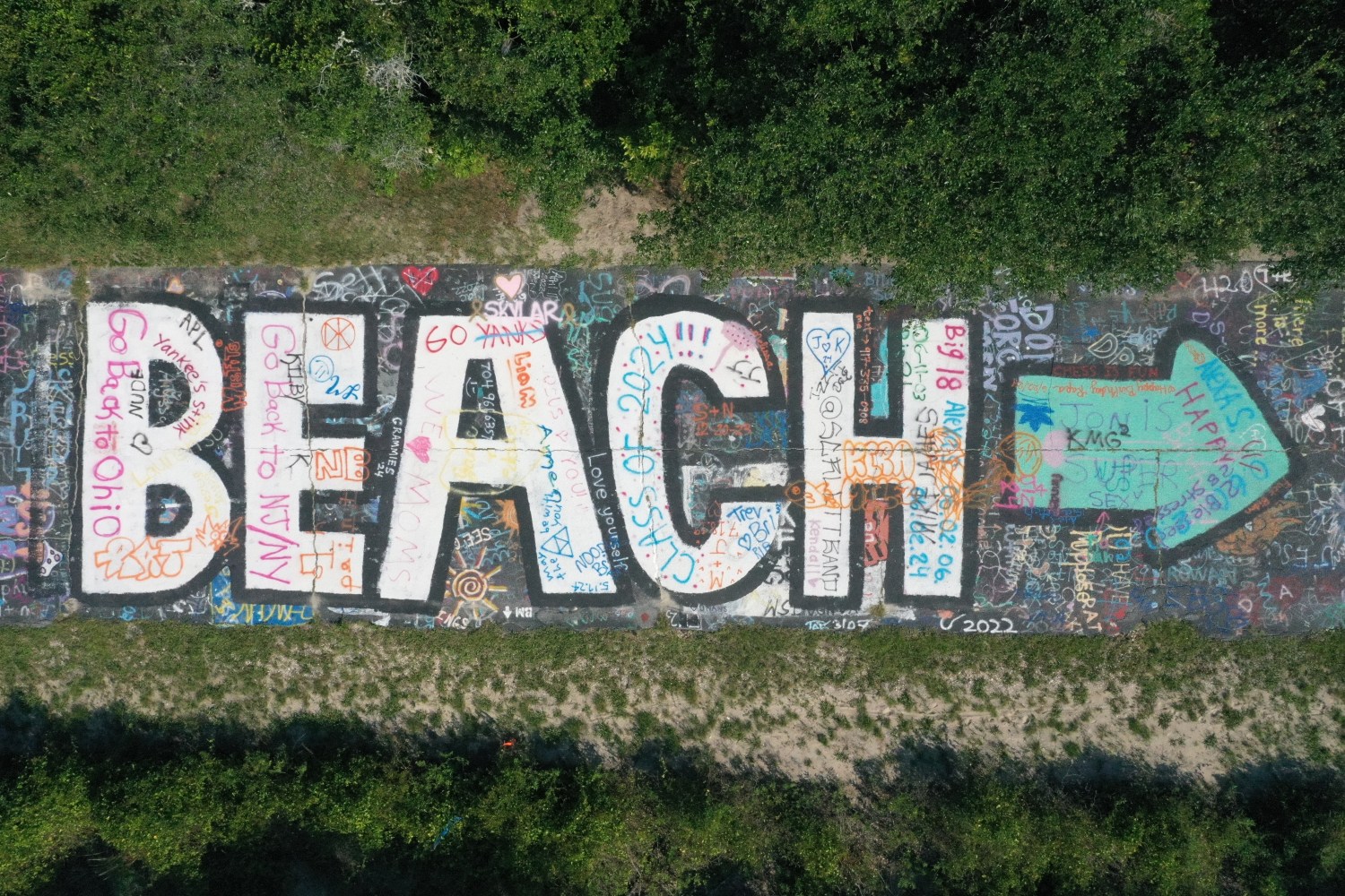
Graffiti Beach
At the far northeastern end of Folly Beach, where the paved streets give way to sandy paths, weathered coastal landscapes, and sweeping views of the Atlantic, you’ll find a side of Folly that feels a world away from the busy downtown beach scene. Locals often refer to this area as the Old Coast Guard Station, and it’s one of the most fascinating places to explore if you love a little adventure mixed with history, wildlife, and a healthy dose of beach-town weirdness.
Here, you can wander the graffiti-covered path, watch dolphins cruise through the inlet, catch a spectacular sunrise, and gaze across the water at the iconic Morris Island Lighthouse. It’s also a place where Civil War history, shipwreck legends, pirates, erosion, and modern pop culture all come together. If you’re looking for the wilder side of Folly Beach, this is a great place to start.
Finding the Old Coast Guard Station
The northeastern end of Folly Beach is a different experience from the main public beach near Center Street. The atmosphere is quieter and more untamed, with dunes, maritime vegetation, tidal waterways, and long stretches of sand that change with the weather and tides.
The Old Coast Guard Station area is especially popular with people who want to get away from the crowds, take photographs, explore the shoreline, or simply sit and watch the water. It’s not a manicured tourist attraction with neat paths and interpretive signs at every turn. Part of its appeal is that it feels a little undiscovered.
Parking requires some planning. The eastern end is reached by following East Ashley Avenue toward the inlet. Parking is limited near the end of the road, and spaces can fill quickly during busy beach days. Pay close attention to posted signs and don’t block driveways, private access, or emergency routes. Don’t assume you can park on a sandy shoulder just because another vehicle is there. If the available spaces are full, park legally farther back and walk in. Check current local parking rules before your visit, particularly during peak season. All 4 tires off the road and park with the flow of traffic.
Bring comfortable walking shoes, water, sunscreen, and a camera. The terrain can be soft, uneven, or muddy depending on recent weather and tides, and the shoreline may look quite different from one visit to the next.
Graffiti Path: A Little Color at the Edge of the Island
One of the area’s most recognizable features is the informal route many visitors call Graffiti Path. The colorful markings and weathered surfaces give the walk a distinctly Folly character: creative, imperfect, a little rebellious, and never too polished.
It’s a fun place to take photographs, explore the textures and colors, and get a feel for the more unconventional side of the island. Unlike a formal mural district, this is part of a changing coastal environment. The artwork and surrounding landscape can change, and not every marked surface is necessarily intended as a public art installation.
Enjoy the walk, but be respectful. If you are going to add graffiti make sure it’s tasteful.
The best way to experience Graffiti Path is to take your time, look around, and appreciate the contrast between human creativity and the constantly changing natural landscape. It’s a reminder that Folly has always attracted people who like their beach experiences a little less ordinary.
The Morris Island Lighthouse: Folly’s Iconic View
One of the biggest reasons to visit this part of Folly is the view of the Morris Island Lighthouse, standing offshore at the entrance to Charleston Harbor. Its tall brick tower rises out of the water, surrounded by shifting sand and waves. It looks almost surreal, especially when the light catches the tower against a blue sky or paints the horizon in shades of orange and pink.
The lighthouse has a remarkable history. The first lighthouse on Morris Island was built in 1767 to help guide ships safely into Charleston Harbor. After the original structures were lost and replaced through the years, the current 161-foot tower was completed in 1876. Today, the water and erosion have left it isolated offshore, a dramatic reminder that the coastline is never truly stationary. visitfolly.com .
You can’t simply walk out to the lighthouse from the beach. It’s separated from shore by water, and visiting it up close requires an appropriate boat excursion (aka a tour with Flipper Finders). But the view from the northeast end of Folly is reason enough to bring your camera.
Sunrise at the Edge of Folly
If you can manage an early start, sunrise is one of the most rewarding times to visit. The eastern horizon begins to brighten, the lighthouse becomes a silhouette, and the beach takes on a peaceful quality that can be hard to find later in the day.
Bring a coffee, find a comfortable spot on the sand, and give yourself time to watch the colors change. Photographers will appreciate the contrast between the lighthouse, the water, and the beach’s weathered trees. Even if you’re not taking pictures, it’s a lovely place to slow down and start the day.
Check the sunrise time before heading out, and remember that the final stretch may involve walking on uneven sand. The tide, wind, and surf can change the experience, so keep a safe distance from the water’s edge and avoid walking onto unstable structures or dunes.
Boneyard Beach: Where the Shoreline Leaves Its Mark
Nearby, you’ll find the landscape commonly called Boneyard Beach. Here, dead trees and exposed root systems lie scattered across the sand, creating an almost otherworldly scene. Bleached trunks, twisted branches, and skeletal roots make it one of the most distinctive photographic spots in the Charleston area.
The name sounds spooky, but the explanation is rooted in coastal change. Trees that once grew farther inland have been killed or undermined as the shoreline has shifted. Waves, tides, storms, and erosion gradually expose roots and carry away the ground that once supported them. The result is a striking landscape that looks like nature’s own sculpture garden.
Folly Beach has struggled with erosion for decades. Changes to sediment movement associated with the Charleston Harbor jetties, along with storms and other natural processes, have contributed to shoreline loss. The city and the U.S. Army Corps of Engineers have carried out beach nourishment projects to help protect the island, but no project can freeze a barrier island in place. cityoffollybeach.com .
That changing landscape is part of what makes Boneyard Beach so fascinating—and why it deserves respect. Don’t climb on dead trees or pull apart the remains for souvenirs. Some surfaces are unstable, and the best photographs come without disturbing the scene.
Dolphins, Shorebirds, and Other Coastal Neighbors
The waters around the inlet are also a wonderful place to watch for wildlife. Bottlenose dolphins live in the waters around Folly Beach, and you may spot a dorsal fin cutting through the inlet or see dolphins surfacing as they move along the shoreline. Sightings are never guaranteed, which is part of the fun: keep your eyes on the water and enjoy whatever the day brings.
Shorebirds work the shallows and beach, looking for small fish and other food. Depending on the season, you may see pelicans gliding low over the waves, gulls riding the wind, or other coastal birds resting along the waterline. The dunes and surrounding habitats also support sensitive wildlife, including nesting sea turtles and shorebirds.
Give wildlife plenty of space. Never feed dolphins, chase them, or try to swim toward them. Keep clear of nesting areas and obey posted signs. Take your rubbish with you, too—what blows away on the beach can end up in the marsh or ocean.
The best wildlife watching often comes from simply standing still and paying attention. You don’t need a boat or binoculars to enjoy the natural life of the inlet, although binoculars can make distant sightings more rewarding.
From Quarantine Island to Civil War Encampment
The landscape is beautiful today, but Folly’s past is far more complicated than its relaxed beach-town reputation suggests.
The island was once known as Coffin Island, although the origin of that name remains debated. Some accounts connect it to the Coffin family, while local stories link it to shipwrecks, disease, and the dead brought ashore. The name has become part of Folly’s folklore, and the island’s history certainly gives it a haunting edge. visitfolly.com .
One of the best-documented stories involves the Amelia, a ship that wrecked near Folly in 1832. Around 120 survivors reached shore, but some were suspected of having cholera. Authorities restricted movement and supplies to prevent the disease from spreading into Charleston. The episode turned the island into a place of quarantine and suffering, and many survivors died. Over time, this tragedy helped fuel the island’s darker legends. cityoffollybeach.com .
Folly’s importance grew dramatically during the Civil War. Beginning in 1863, Union forces occupied the island and transformed it into a major military staging area. Soldiers built roads, fortifications, artillery positions, and supply depots among the dense vegetation. Thousands of troops were stationed here as the Union campaign against Charleston intensified.
Folly served as a base for operations against nearby Morris Island, including the campaign for Fort Wagner. The famous 54th Massachusetts Volunteer Infantry Regiment, one of the Union Army’s best-known Black regiments, fought at Fort Wagner. The 55th Massachusetts and other Union troops also served on Folly.
The past isn’t just written in history books. In the years after the war, erosion and storms exposed artifacts from military camps buried beneath the island’s shifting ground. In 1987, the remains of 19 Union soldiers were discovered on Folly, and archaeological investigations recovered additional evidence of the wartime encampments. Hurricane Hugo later uncovered more Civil War-era materials. charlestonmuseum.org .
So when you walk along the northeastern shoreline, remember that the dunes and vegetation conceal layers of history. What looks like an ordinary stretch of beach may have once been part of a military camp, a supply route, or a landscape crossed by soldiers preparing for battle.
Pirates, Shipwrecks, and Buried Treasure
No story about Folly would be complete without pirates.
During the age of piracy, the South Carolina coast was busy with merchant ships, colonial trade, and vessels navigating the challenging waters around Charleston Harbor. The maze of inlets, islands, and waterways offered places to hide, and notorious figures such as Blackbeard, whose real name was Edward Teach, became part of regional pirate lore.
Folly’s history includes plenty of shipwrecks, and its reputation for hidden treasure has endured for generations. One local legend tells of pirate treasure buried near Morris Island, sometimes accompanied by tales of ghostly guardians and unlucky treasure hunters. These stories are entertaining, but it’s important to separate folklore from documented history: there is no verified evidence of a buried Blackbeard fortune on Folly.
Still, it’s easy to see why the stories persist. Picture a ship approaching Charleston Harbor centuries ago, navigating shifting sandbars and rough water, with a storm rolling in offshore. A wreck, a lost cargo, or a crew forced to abandon ship could leave behind mysteries that the sea might never fully reveal.
And the shoreline still gives up surprises. After Hurricane Dorian in 2019, visitors discovered Civil War-era cannonballs near the old Coast Guard area. Earlier storms had exposed other military artifacts. The beach is a reminder that erosion can uncover history as quickly as it can erase it. visitfolly.com .
Enjoy the treasure stories, keep your imagination open, and leave any historical objects where they are. If you come across a possible artifact, photograph it and report it to the appropriate authorities rather than taking it home.
Modern Day Folly Beach Treasure Hunt. https://www.thesoutherntrapper.com/pages/treasure-hunt
The Old Coast Guard Station and Lighthouse Inlet Heritage Preserve
The area known as the Old Coast Guard Station is now associated with Lighthouse Inlet Heritage Preserve, a protected natural area at the northeastern end of Folly Island. It provides access to a remarkable stretch of coast and views toward Morris Island Lighthouse.
One important detail for visitors: the preserve is not an unrestricted playground. Public access is limited to designated areas, including the main paved route toward the inlet and the beach. Follow signs and stay out of closed or restricted sections. The old station area and surrounding landscape have changed over time, so don’t assume every visible path or structure is open to visitors. carolinabirdclub.org .
This is a place to appreciate the environment as much as the history. The dunes, beach, and inlet are constantly reshaped by tides and weather. Salt, wind, and water slowly wear away at the land, while storms can dramatically alter the shoreline in a single night.
That erosion is part of the area’s beauty, but it also means conditions can be unpredictable. Keep a safe distance from collapsing banks, exposed roots, and unstable structures. Avoid walking on dune vegetation, which helps stabilize the sand, and never enter a closed area simply to get a better photograph.
Folly Beach and Netflix’s Outer Banks
If the lighthouse and pirate legends feel familiar, there’s a good reason: the Charleston area has played a starring role in Netflix’s hit series Outer Banks.
Despite the show’s name, much of the series was filmed around Charleston and the surrounding Lowcountry. Folly Beach’s marshes, waterways, coastal scenery, and small-town atmosphere helped create the fictional world of Kildare Island. The real Morris Island Lighthouse also appears as the show’s lighthouse, tying the series to this part of the coast. visitfolly.com .
Fans love exploring the locations that appear on screen, and the northeastern end of Folly makes a memorable stop for anyone interested in the area’s scenery. The combination of the lighthouse, weathered trees, tidal water, and historic landscape has the same cinematic quality that makes the Lowcountry so appealing on television.
But remember that Outer Banks is fiction. The show’s treasure hunts and dramatic adventures draw on the region’s real history and coastal atmosphere, but they shouldn’t be confused with documented events. The best part is getting to experience the actual landscape that inspired the look and feel of the series.
Tips for Visiting the Northeast End of Folly Beach
A little planning can make your visit much more enjoyable.
- Arrive early. Sunrise offers beautiful light, quieter beaches, and a better chance of finding available parking.
- Check the tide and weather. High water, strong surf, and recent storms can change beach access and the shape of the shoreline.
- Plan for parking. Use designated paid lots or legal street parking, and confirm current rates and rules at parkfollybeach.org . All four tires must be off the roadway when parking along the street, and parking on dunes or revetments is prohibited.
- Bring essentials. Water, sunscreen, a hat, comfortable shoes, and a camera are all useful.
- Respect wildlife and history. Don’t approach dolphins, disturb nesting birds or turtles, remove artifacts, or damage the dunes.
- Leave no trace. Take your rubbish with you and leave the beach as you found it.
A Different Side of Folly Beach
The northeastern end of Folly Beach is more than a scenic spot for a photograph. It’s a place where the island’s many identities overlap: a former quarantine destination, a Civil War st